

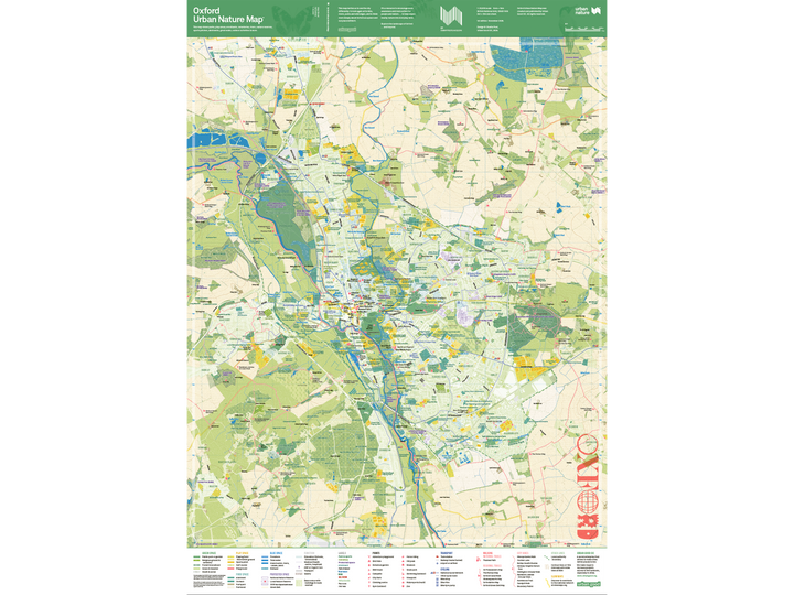


Discover Oxford’s greener side. A wall map for walking, cycling, city hikes and everyday adventures.
Forthcoming — pre-order now for the first copies off the press.
Publication date: 19 November 2026. We’re aiming to post pre-orders on 16 November 2026.
See Oxford Differently
Follow a river, explore a woodland or find a new way through a familiar neighbourhood. The Oxford Urban Nature Map invites you to look more closely at the living landscape around you.
This wall map gives you space to see the bigger picture: how parks connect with paths, how waterways wind through the city, and where your next adventure might begin. Spread it out to plan a day together, then fold it up and take it with you.
Whether you live in Oxford, study here or are visiting for the first time, there’s plenty to discover.
Oxford Trails & City Hikes
Explore the walking routes marked on the map, from local paths and woodland trails to sections of longer routes connecting Oxford with the wider countryside.
National Trail
Thames Path: Follow the river through Oxford and out into the surrounding meadows and countryside.
Regional Trails
St Frideswide’s Way: A pilgrimage route connecting Oxford with Reading, beginning at the shrine of Oxford’s patron saint in Christ Church Cathedral.
The Roman Way: A long-distance walk following the course of Roman roads, passing beside Oxford and across Otmoor.
Oxford Canal Walk: Follow the canal towpath north from Oxford towards the surrounding countryside.
Shakespeare’s Way: Explore Oxford’s stretch of the walking route linking Stratford-upon-Avon with London’s Globe theatre.
Oxfordshire Way: Discover local sections of a cross-country trail linking the Cotswolds with the Chilterns and Henley-on-Thames.
Oxford Green Belt Way: A circular trail through the countryside surrounding Oxford, connecting villages, waterways and views back towards the city.
City Hikes & Local Walks
Mesopotamia Walk: A tree-lined footpath along a narrow island between two branches of the River Cherwell.
Cuckoo Lane: Discover an old route through Headington, with green stretches tucked between the surrounding streets.
Botley Health Routes: Neighbourhood walks connecting parks, meadows and woodland west of Oxford.
Hinksey Heights Nature Trail: Explore woodland, reedland and fen, with views across to the city.
Kidlington Circular Walk: A loop taking in the Cherwell floodplain, historic ruins and the Oxford Canal.
Ramblers Jubilee Circular Walk: A longer outing through the Hinksey uplands, linking field paths, hills and views over Oxford.
Northwood Trail, Sandpit Walk & Boundary Patrol: Three routes offering different ways to explore Shotover Country Park, from a shorter wander to a longer circuit.
Made for your walls
This is the flat and un-folded version that is ready for framing or pinning to your wall. The folded version can be found here.
For your walls or frames
Order the flat, uncreased and limited edition prints here. It's the same map, printed single sided and rolled in a sturdy tube. Ideal for mounting or framing. These are signed, stamped and numbered 1/1000.
Map Specifications & Features
Large A1 format: Opens to 594 × 841 mm in portrait orientation, giving you a detailed overview of Oxford and its surrounding green spaces.
Easy to take with you: Folds into 24 panels, down to approximately 105 × 198 mm.
Detailed mapping: A scale of 1:20,000 — 1 cm on the map represents 200 metres on the ground.
Specialist map printing: Printed on the same high-specification press used for Ordnance Survey maps.
Fluorescent Pantone inks: Vivid colours bring Oxford’s landscape to life on durable map paper made for folding, marking up and taking outdoors.
Nature atlas on the reverse: Seasonal inspiration, small adventures and ways to discover and care for Oxford’s wildlife.
Publication date: 19 November 2026.
ISBN: 9781914432194.
Current local stockists
Once the map is stocked by local shops we will keep a list here.